Geotechnical Instrumentation Increases Stability and Safety

Certain construction projects have more risk of adverse consequences than others.
Projects involving tunneling or large transportation embankment fills, for instance, have a higher risk of collapse, landslides, or settlement. This may lead to damage to existing structures. Especially as the soil is disturbed, the ground can become less stable, increasing risk of adverse effects.
Geotechnical instrumentation monitors subsurface features and provides data regarding the effects of the construction process. Engineers use the monitoring data to verify assumptions made during design and detect impending failures or unacceptable movements. By using geotechnical instrumentation, many clients are able to reduce liabilities for the construction project.
By combining initial geotechnical analyses with instrumentation during construction, CTL Engineering can help verify that subsurface conditions during and after the construction process are acting consistently with the design assumptions.
What is Geotechnical Instrumentation?
Geotechnical instrumentation programs typically begin before construction starts to provide baseline measurements. Then, an engineer uses instrumentation data during construction to monitor subsurface features – looking for any unexpected or unacceptable movement. Post-construction, additional measurements help verify the conditions of the site.
CTL Engineering has a variety of Geotechnical Instrumentation capabilities. Three of the most commonly used include:
1. Inclinometers
Inclinometers detect lateral movement in soils and bedrock.
CTL Engineering installs an inclinometer casing into soil or bedrock to depths below the anticipated movement zone. Inside the casing, an inclinometer probe measures lateral movement over time to determine if the soil or bedrock is moving. Often, CTL uses inclinometers next to deep excavations to watch for soil movement and alert contractors prior to a potential failure of the excavation shoring. An engineer may also use inclinometers in areas adjacent to a high fill to detect soil movement that may indicate a potential slope failure. Additionally, inclinometers are also used within known slope failures to identify the slip surface allowing proper design for remediation measures.
2. Extensometers
Extensometers monitor for vertical movements in the soil or bedrock.
To install extensometers, CTL grouts anchors into boreholes and connects them to a measuring device at the surface. If the soil or bedrock stratums move, the tool alerts contractors to collapsing soils or bedrock near deep excavations. This allows the contractor to detect subsurface movements early and take the necessary precautions, typically well before a surface expression would indicate a subsurface issue.
3. Monitoring Wells / Piezometers
Monitoring wells and piezometers monitor groundwater levels and pore pressure within the soil.
An engineer may monitor groundwater levels during construction to determine the effectiveness of dewatering efforts or determine the effect of construction activities on the natural groundwater levels. Often, as construction crews place fills over clay soils, pore pressures rise within the clay soils and reduce the shear strength of the soils. Reduced strengths due to the rise in pore pressures may lead to foundation bearing failures or slope failures. An engineer may use piezometers to determine the pore pressure changes and determine when construction activities, such as additional fill placement, may resume.
Other types of Instrumentation
As one of the leading geotechnical instrumentation providers, CTL uses decades of experience to plan for a project’s needs. CTL has worked throughout Ohio, Indiana, West Virginia, Virginia, Pennsylvania, and Kentucky, forming instrumentation plans to monitor critical areas of the project.
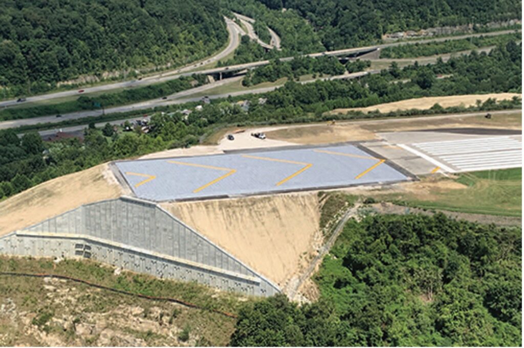
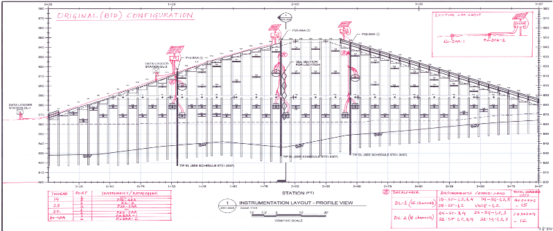
In 2015, one of the tallest engineered slopes in the United States — at the end of Runway 5 at the Charleston Regional Airport in West Virginia — experienced a landslide.
While reconstruction was happening, CTL used a combination of ShapArray inclinometer-style sensors, VW load cells, strandmeters, strain gauges, and multiple borehole extensometer sensors to effectively monitor the site.
As a result, crews were able to safely repair the slope to restore runway operations.
On each project, CTL engineers recommend the appropriate combination of instrumentation, and monitoring critical subsurface conditions during construction and long after the project is finished. The result is CTL engineers are able to help clients manage construction risks.