Electrical Resistivity

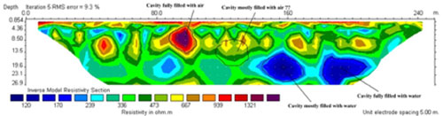
In Keeping with our diversity of services, in addition to Ground Penetrating Radar (GPR) and Refraction Microtremor (ReMi), CTL Engineering has purchased Electrical Resistivity Imaging equipment to round out our geophysical survey capabilities. Electrical Resistivity (ER) involves measuring the resistivity of subsurface features along a single profile or a series of profiles to locate and/or identify features, such as karst, voids, buried structures, tanks, differing geology, groundwater sources, burial plots; as well as analyses of volumetric aggregate resources, aquifers, and bedrock features. Some applications include borehole-to-borehole tomography and underwater measurements in rivers, lakes, dams and the sea to investigate bottom conditions.
Electrodes are typically planted into the earth with the length of profile, depth of penetration, and resolution determined by the electrode spacing, which can be anywhere from 1 meter to 50 meters (3 feet to 165 feet) or more. Resistivity measurements are made by placing a known current into the ground and the resulting potential is measured. By changing relative spacing or locations between the potential and current electrodes, different resistivity measurements can be made. Once the resistivity data sets have been acquired, they are processed for recognition of variations in subsurface materials and apparent moisture content and then processed and mapped to provide insight into the subsurface materials.
Electrical Resistivity is another way CTL can save the client time and money because it is easy to use and cost efficient.